Os cookies.
Este site utiliza cookies para lhe proporcionar uma melhor experiência de utilização.
OK, ACEITO
Sobre
Itens da coleção
Refinar a pesquisa
Coleções digitais
Biblioteca Geral
178
Mapas Nabais Conde
175
Botânica
169
500 Anos da Biblioteca
2
Rómulo Digital
2
Ver mais
Tipo
Cartografia
159
Manuscrito
156
Gravuras e Desenhos
16
Livro Moderno
9
Correspondência
8
Ver mais
Autor
Walker, J. & C.
24
Prain, David
19
Thiselton-Dyer, William Turner
18
Fairchild, David Grandison
14
Vidal, Alexander Thomas Emeric
14
Ver mais
Data
1955-1974
23
1910-1915
23
1884-1889
20
1842-1873
23
1752-1783
22
Ver mais
Local de publicação
Londres
181
Kew
28
Washington
24
Kew, Londres
16
Melbourne
8
Ver mais
Assunto
Mapa
79
Plantas
68
Portugal
46
Envio
40
Classificação
34
Ver mais
Idioma
Inglês
PT
EN
PT
EN
Biblioteca de Fundo Antigo da UC
Almamater
Em destaque
Todos os itens
Sobre
Nesta coleção
Pesquisa avançada
Refinar a pesquisa
Limpar
Coleções digitais
Biblioteca Geral
178
Mapas Nabais Conde
175
Botânica
169
500 Anos da Biblioteca
2
Rómulo Digital
2
Ver mais
Tipo
Cartografia
159
Manuscrito
156
Gravuras e Desenhos
16
Livro Moderno
9
Correspondência
8
Ver mais
Autor
Walker, J. & C.
24
Prain, David
19
Thiselton-Dyer, William Turner
18
Fairchild, David Grandison
14
Vidal, Alexander Thomas Emeric
14
Ver mais
Data
1955-1974
23
1910-1915
23
1884-1889
20
1842-1873
23
1752-1783
22
Ver mais
Local de publicação
Londres
181
Kew
28
Washington
24
Kew, Londres
16
Melbourne
8
Ver mais
Assunto
Mapa
79
Plantas
68
Portugal
46
Envio
40
Classificação
34
Ver mais
Idioma
Inglês
Itens
350
Ver como
Galeria
Lista
Grelha
Ordenar por
Data (de publicação)
Título
Título (descendente)
Data (descendente)
Páginas
1
2
3
4
Limite por página
50
100
250
Cartografia
Spaine newly described with many adictions, both in the attires of the people & the setuations of their cheifest cityes
Cartografia
A chart of Spaine : perticulerly discribing the coasts of Biscaia Gallissia Portugal Andaluzia Granada Ec
Cartografia
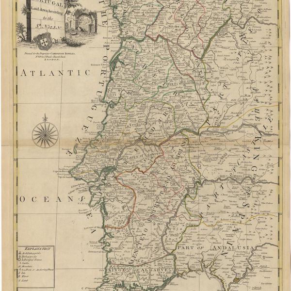
A new map of Portugal
Cartografia
The Coast of Portugal from River de Sinis to Siluis ; The coast of Andalousie from Siluis to Pallos.
Cartografia
A new map of Iberia Europaea alias Celtiberia, or Ancient Spain : shewing its principal divisions, cheif cities, townes, rivers, mountains & c[?]. Dedicated to His Highness William Duke of Gloucester
Cartografia
A new map of present Spain & Portugal : shewing their principal divisions, cheif cities, townes, rivers, mountains & c. : Dedicated to His Highness William Duke of Gloucester
Cartografia
A correct map of Spain & Portugal : according to the newest observations and discoveries comunicated to the Royal Society at London and the Royal Academy at Paris is humbly dedicated to the Right Honorable Iohn Ld. Somers Baron of Evesham
Cartografia
Island of Madera
Cartografia
Spain and Portugal
Cartografia
Portugal : agreeable to modern history
Cartografia
A new and accurate map of Spain and Portugal : drawn from the best Authorities
Livro Antigo
Micrographia illustrata, or, The knowledge of the microscope explain'd together with an account of a New Invented Universal, single or double, Microscope, either of which is capable of being applied to an Improv'd Solar Apparatus. This Treatise contains a Description of the Nature, Uses, and Magnifysing Powers of Microscopes in general; together with full Directions how to prepare, apply, and examine, as well as preserve, all Sorts of minute Objects also an account of The principal Microcopical Discoveries, that have hirherto been mentioned by the most celebrated Authors, togeher with a great Variety of new Experiments and Observations. The whole being, as it were, A Natural History of a Multitude of Aerial, Terrestrial, and Aquatick Animals, Seeds, Plants, Etc. To which is added, A Translation of Mr. Joblott's Observations on the Animalcula, that are found in many different Sorts of Infusions and a very particular Account of the surprising Phaenomenon, The Fresh Water Polype, translated from the French Treatise of Mr. Trembley. This Work is compiled for the Assistance of those, who are desirous of surveyng the extensive Beauties of the minute Creation and is illustreted with 65 Copper-plates, curiously engrav'd, wich contain above 560 Pictures of Microscopic Objets
Cartografia
A new and accurate map of Portugal : composed from the latest improvem.ts and adjusted by the most authentic astron. observats.
Cartografia
A new map of Spain & Portugal from the latest observatio[ns].
Cartografia
Island of Madera ; The Dragon Tree
Gravuras e Desenhos
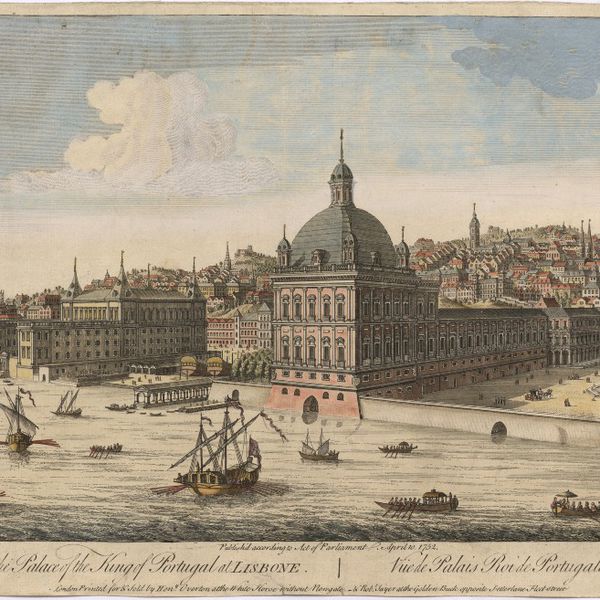
A view of the Palace of the King of Portugal at Lisbone = Vüe de Palais Roi de Portugale à Lisbon
Cartografia
A Chart of the Açores (Hawks) Islands, called also Flemish and Western Islands from Mr. D'Anviille with several additions.
Cartografia
A plan of the city of Lisbon with the Harbour, Forts, Depth of Water and Country adjacent : for the Lond. Mag.
Cartografia
Spain and Portugal. A map of the mouth of the River Tagus or harbour of the city of Lisbon
Gravuras e Desenhos
Ruins of Lisbon after the Earth-Quake on the 1st. Nov.br 1755 : The Opera House
Cartografia
A Map of the River Tale to Lisbon Done from a New Survey
Cartografia
A chart of the sea coasts of Algrave [sic] and Andalusia between cape St. Vincent and the strait of Gibralter and c. Spartel
Gravuras e Desenhos
A general view of the city of Lisbon, the capital of the Kingdom of Portugal as it stood on the North side of the river Tagus or Tajo before the late earthquakes, on November 1.st & 8.th 1755
Cartografia
The theatre of war in Portugal with the distances of the fortified towns, from Lisbon
Cartografia
Portugal
Cartografia
A map of the Kingdom of Portugal
Cartografia
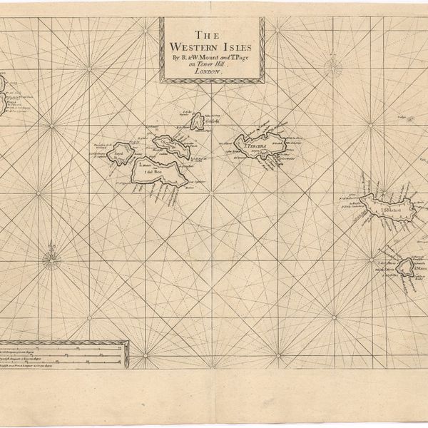
The Western Isles
Cartografia
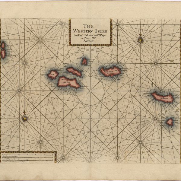
The Western Isles
Cartografia
A new and correct chart of the coast of Portugal from Cape Stan to Cape Montego ; A new and correct chart of the coast of Portugal from Cape Montego to Pont de Faro
Livro Antigo
The mourning bride : a tragedy
Cartografia
Spain and Portugal
Cartografia
Chart of the Açores (Hawks) Islands, called also Flemish and Western Islands.
Cartografia
A Chart of the Maderas and Canary Islands : from the Draughts and Memoirs of Captn. George Glas : Regulated and Ascertained by Astronomical Observations.
Cartografia
Map of South America : For the Ver. Dr. Robertson's History of America
Cartografia
Bowles's new pocket map of Portugal
Gravuras e Desenhos
A general view of Lisbon, the capital city of Portugal
Cartografia
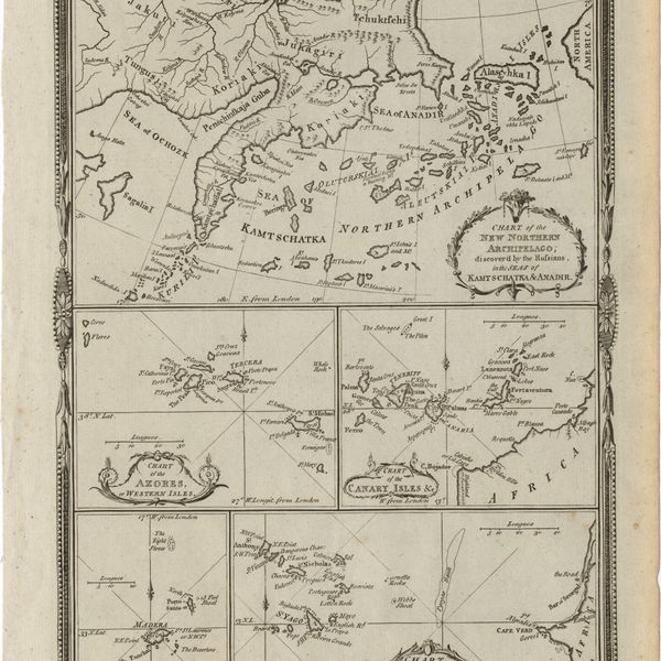
Various charts of islands &c., in the Atlantic & Pacific Oceans
Cartografia
The Kingdoms of Portugal and Algarve from Zannonïs Map
Cartografia
The Kingdoms of Portugal and Algarve from Zannonïs Map
Gravuras e Desenhos
Ruins of Lisbon after the Earthquake in 1755 : engraved for Barlows General History of Europe
Cartografia
Chart of the Açores (Hawks) Islands, called also Flemish and Western Islands.
Cartografia
Chorographical map of the kingdom of Portugal divided into its grand provincies = Mappa corografico do Reino de Portugal
Gravuras e Desenhos
Coimbra in Portugal
Gravuras e Desenhos
Coimbra : Fig. 197
Cartografia
Europe
Livro Moderno
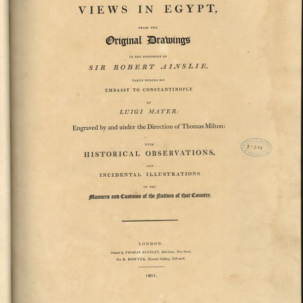
Views in Egypt, from the original drawings in the possession of Sir Robert Ainslie, taken during his embassy to Constantinople by Luigi Mayer
Cartografia
A new map of the Kingdom of Portugal divided into its provinces
Cartografia
Portugal
Cartografia
Portugal
Cartografia
Chart of the Island of St. Michael
Cartografia
Portugal including Algarve
Cartografia
A new military map of Portugal : the roads from the Carta Militar published by the french in Lisbon : the rivers and mountains from the last Authorities
Cartografia
A new military map of Portugal : the roads from the Carta militar published by the french in Lisbon, the rivers and montains, from the best authorities
Cartografia
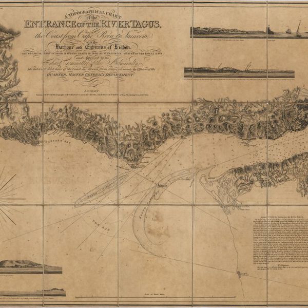
A topographical chart of the entrance of the river Tagus, describing the coast from Cape Roca to Sacavem ; with the harbour and environs of Lisbon. The nautical part is from a survey taken in 1806 by W. Chapman, Master of the Royal Navy; and approved by the Chart Committee of the Admiralty. The interior and line of the coast are drawn from survays made by officers of the Quarter Master General's Department
Cartografia
A new map of Spain and Portugal : exhibiting the chains of mountains with their passes, the principal & cross roads, with other details requisite for the intelligence of Military Operations
Cartografia
A new map of Spain and Portugal : exhibiting the chains of mountains with their passes, the principal & cross roads, with other details requisite for the intelligence of Military Operations
Cartografia
A Military sketch of the country between Lisbon and Vimiero occupied by the British Army under the command of Lieutenant General Viscount Wellington
Cartografia
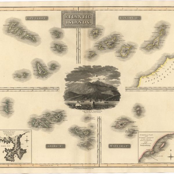
Atlantic islands
Cartografia
The present seat of war in Portugal : with the positions of the French and allied armies.
Cartografia
A new map of the kingdoms of Spain and Portugal with their principals divisions.
Cartografia
Portugal
Cartografia
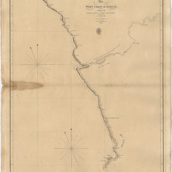
The West Coast of Africa : Sheet XVII from Banda Point to St. Paul de Loanda including the Congo
Cartografia
Africa : Sheet III : from Annabona to Hollams Island in Latde. 24º 36' S
Cartografia
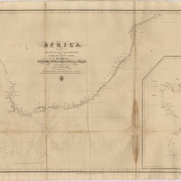
Africa : Sheet IV : from Hollams Island to Cape Corrientes including the Cape of Good Hope
Cartografia
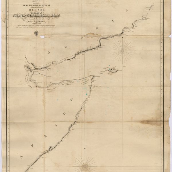
Africa : Sheet VI : from the Juba Islands to Muscat : with the Entrance to the Red Sea
Cartografia
Map of Portugal
Cartografia
Africa : Sheet V : from Cape Corrientes to Juba Islands including Madagascar, Comoro, Zanzibar, Ids. & c.
Cartografia
Spain and Portugal
Cartografia
Africa : Sheet II : from the River Gambia to cape Lopez and Annabona including the Bight of Biafra
Cartografia
Portugal
Cartografia
Spain & Portugal. Western Part
Cartografia
Madrid
Gravuras e Desenhos
Belem castle, Lisbon
Cartografia
Plan of the town and environs of Porto
Cartografia
West Coast of Africa : Sheet VI : Cape Verde to Cape Roxo including the Gambia
Cartografia
West Coast of Africa : Sheet VII : from Cape Roxo to Isles de Los
Gravuras e Desenhos
Se Velha, or old Cathedral : Coimbra
Gravuras e Desenhos
Coimbra
Gravuras e Desenhos
Coimbra : looking over the gardens of Santa Cruz
Gravuras e Desenhos
[Coimbra]
Gravuras e Desenhos
Coimbra from the east
Cartografia
The Delta of the River Kowara or Quorra, the ancient Niger
Cartografia
West Coast of Africa : Sheet I : Cape Spartel to Mazighan
Cartografia
A chart of the West Coast of Africa : Sheet VIII : the Isles de Los to Sherboro Island
Gravuras e Desenhos
Oporto : Ms. C. L. Nº 1319
Cartografia
West Coast of Africa : Sheet XI : Cape Palmas to Grand Lahou
Cartografia
West Coast of Africa : Sheet IX : Sherboro Island to Cape Mesurada
Cartografia
West Coast of Africa : Sheet XII : Grand Lahou to Cape Three Points
Cartografia
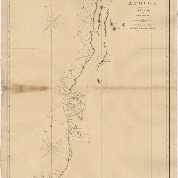
West Coast of Africa : Sheet XVIII : Fernando Po to Cape Lopez
Cartografia
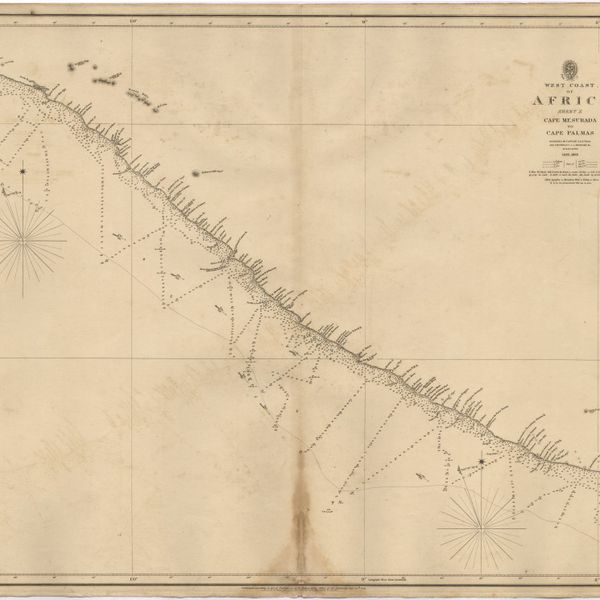
West Coast of Africa : Sheet X : Cape Mesurada to Cape Palmas
Cartografia
West Coast of Africa : Sheet XIII : Cape Three Points to Barracoe
Cartografia
West Coast of Africa : Sheet XIV : Barracoe to Cape St. Paul
Cartografia
West Coast of Africa : Sheet XVII : Cape Formosa to Fernando Po
Cartografia
West Coast of Africa : Sheet II : Azamor to Sta. Cruz
Cartografia
West Coast of Africa : Sheet IV : Cape Bojador to Cape Blanco
Cartografia
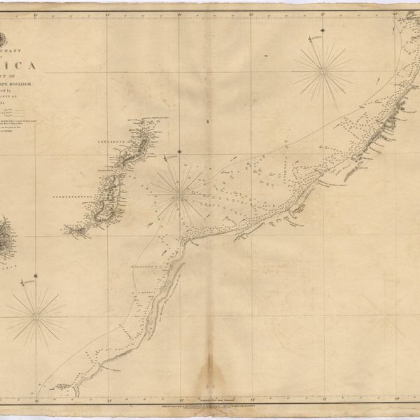
West Coast of Africa : Sheet III : Sta. Cruz to Cape Bojador
Cartografia
West Coast of Africa : Sheet V : Cape Blanco to Cape Verde
Cartografia
Steel's new and correct chart of the coasts of Spain and Portugal : including plans at the principal harbours on an enlarged scale
Cartografia
Spain and Portugal
Cartografia
Spain and Portugal