Os cookies.
Este site utiliza cookies para lhe proporcionar uma melhor experiência de utilização.
OK, ACEITO
Sobre
Itens da coleção
Refinar a pesquisa
Coleções digitais
Biblioteca Geral
178
Mapas Nabais Conde
175
Botânica
169
500 Anos da Biblioteca
2
Rómulo Digital
2
Ver mais
Tipo
Cartografia
159
Manuscrito
156
Gravuras e Desenhos
16
Livro Moderno
9
Correspondência
8
Ver mais
Autor
Walker, J. & C.
24
Prain, David
19
Thiselton-Dyer, William Turner
18
Fairchild, David Grandison
14
Vidal, Alexander Thomas Emeric
14
Ver mais
Data
1955-1974
23
1910-1915
23
1884-1889
20
1842-1873
23
1752-1783
22
Ver mais
Local de publicação
Londres
181
Kew
28
Washington
24
Kew, Londres
16
Melbourne
8
Ver mais
Assunto
Mapa
79
Plantas
68
Portugal
46
Envio
40
Classificação
34
Ver mais
Idioma
Inglês
PT
EN
PT
EN
Biblioteca de Fundo Antigo da UC
Almamater
Em destaque
Todos os itens
Sobre
Nesta coleção
Pesquisa avançada
Refinar a pesquisa
Limpar
Coleções digitais
Biblioteca Geral
178
Mapas Nabais Conde
175
Botânica
169
500 Anos da Biblioteca
2
Rómulo Digital
2
Ver mais
Tipo
Cartografia
159
Manuscrito
156
Gravuras e Desenhos
16
Livro Moderno
9
Correspondência
8
Ver mais
Autor
Walker, J. & C.
24
Prain, David
19
Thiselton-Dyer, William Turner
18
Fairchild, David Grandison
14
Vidal, Alexander Thomas Emeric
14
Ver mais
Data
1955-1974
23
1910-1915
23
1884-1889
20
1842-1873
23
1752-1783
22
Ver mais
Local de publicação
Londres
181
Kew
28
Washington
24
Kew, Londres
16
Melbourne
8
Ver mais
Assunto
Mapa
79
Plantas
68
Portugal
46
Envio
40
Classificação
34
Ver mais
Idioma
Inglês
Itens
350
Ver como
Grelha
Lista
Galeria
Ordenar por
Data (descendente)
Título
Título (descendente)
Data (de publicação)
Páginas
1
2
3
4
Limite por página
50
100
250
Cartografia
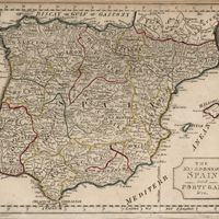
Spain
Estados Unidos da América. Central Intelligence Agency
Cartografia
Iceland : background notes
Estados Unidos da América. Department of State
Cartografia
Mozambique (Portugal)
Cartografia
Iceland
Estados Unidos da América. Central Intelligence Agency
Cartografia
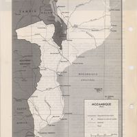
Mozambique : background notes
United States. Department of State. Bureau of African Affairs
Cartografia
Angola : background notes
United States. Department of State. Bureau of African Affairs
Cartografia
Spain : background notes
Estados Unidos da América. Department of State
Cartografia
Portugal : background notes
Estados Unidos da América. Department of State
Cartografia
Portugal
Estados Unidos da América. Central Intelligence Agency
Cartografia
Spain and Portugal
Cartografia
The Seat of War
Cartografia
The Kingdoms of spain and Portugal & Ca.
Cartografia
A map of Portugal
Livro Moderno
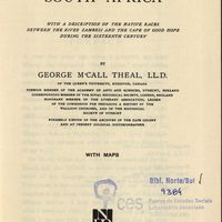
The Portuguese in South Africa; with a description of the native races between the river Zambesi and the Cape of Good Hope during the sixteenth century
Theal, George McCall
Cartografia
Mediterranean Sea : Tunisia : East Coast : Kélibia to Tripoli : principally from french and italian Gouvernment charts to 1954
Collins, K. St. B.
Cartografia
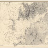
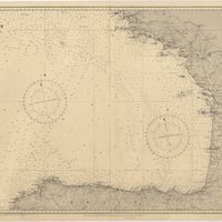
West coast of Spain and Portugal : Cabo Villano to Cabo de S.º Vicente : compiled from the latest information in the Hidrographic Office to 1958
Richards, G. H.
Cartografia
Spain : West Coast : Ria de Vigo : from the spanish government chart of 1912
Parry, J. F.
Cartografia
Mediterranean : Tunisia : North Coast : Lac de Bizerte and Entrance : from french government charts to 1948 : with corrections to 1957
Edgell, J. A.
Cartografia
Mediterranean Sea : Tunisia : East Coast : approaches to Sfax : from the french Gouvernment charts to 1952 : with corrections to 1953
Collins, K. St. B.
Cartografia
Mediterranean Sea : Marocco : Bahia de Ceuta : from the Spanish Gouvernment Chart of 1926 : with corrections to 1956
Douglas, H. P.
Cartografia
Mediterranean Sea : Egypt : Alexandria Harbour
Hardy, N. A. C.; Day, A.; Edgell, J. A.
Cartografia
Portugal : Berlenga to Cabo Espichel including the approaches to Rio Tejo : compiled from portuguese government charts to 1935 : with additions and corrections to 1956
Wharton, W. J. L.
Cartografia
Mediterranean : Tunisia : Baie de Tunis : from the french Gouvernment charts of 1893 : with corrections to 1953
Day, A.
Cartografia
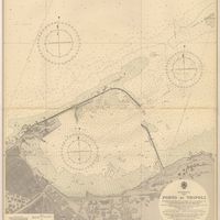
Mediterranean : Libya : Porto di Tripoli
Wyatt, Guy
Cartografia
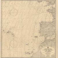
Portsmouth to Canary Islands (Islas Canarias) and the Azores (Açôres) : compiled from the latest information in the hydrographic Department, 1954
Wyatt, A. G. N.
Cartografia
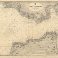
Strait of Gibraltar : from the spanish government charts of 1936 : with corrections to 1953
Edgell, J. A.
Cartografia
France : West Coast : Entrance to La Gironde : from the french government charts of 1887 : with additions and corrections to 1955
Wharton, W. J. L.
Cartografia
Mediterranean Sea : Egypt : approaches to Port Said ; Port Said
Day, Archibald
Cartografia
Mediterranean Sea : plans of the Coast of Libya : Rada and Porto di Tripoli : from the italian Gouvernment chart of 1930
Parry, J. F.
Cartografia
Spain : South Coast : Pta. del Acebuche to Pta. de la Chullera including Gibraltar Bay : from the spanish government charts of 1872-1914
Mostyn, A.
Cartografia
France West Coast : entrance to La Loire and approaches to St. Nazaire : from the French Government Charts of 1893 : with corrections to 1954
Wharton, W. J. L.
Cartografia
Mediterranean Sea : Algérie : C. Ferrat to C. Bougaroni : from the french government surveys of 1868-74 : the coast of Spain from spanish authorities
Richards, G. H.
Cartografia
Mediterranean : Algérie : C. Ivi to Alger : from the french government charts of 1867-1870 : with additions and corrections to 1951
Wharton, W. J. L.
Cartografia
Mediterranean : Gibraltar : surveyed by Capt. R. M. Southern R. N. and officers of H. M. Surveying ship "Challenger" : 1947-1948
Day, A.
Cartografia
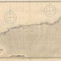
Bay of Biscay : from the latest information in the hydrographic Dept. to 1953
Day, A.
Cartografia
France West Coast : La Loire St. Nazaire to Nantes : from French Government Charts to 1948 : with corrections to 1948
Day. A.
Cartografia
France : West Coast : Pertuis d'Antioche with the approaches to La Rochelle and Rochefort : from the latest french government charts to 1950 : with additions and corrections to 1953
Day. A.
Cartografia
Mediterranean : Algeria : Ports d'Oran and Mers-el-Kébir : from the french government chart of 1876 : with corrections to 1953
Edgell, J. A.
Cartografia
Mediterranean : Africa : C. Tres Forcas to C. Ivi : surveyed by Captain E. Mouchez of the french Navy 1870-73
Wharton, W. J. L.
Cartografia
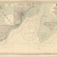
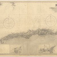
Cape St. Vincent to the Strait of Gibraltar : compiled from the latest government charts
Mostyn, A.
Cartografia
Mediterranean : Israel : Bay of Acre ; Acre Anchorage ; Haifa Harbour
Douglas, H. P.; Edgell, J. A.
Cartografia
France West Coast Sheet V : Bourgneuf to I. de Groix : from the Pilote Francais with corrections from French Government Charts to 1949
Washington, Capitão
Cartografia
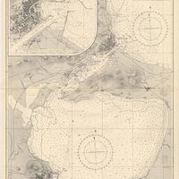
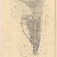
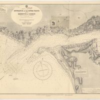
Portugal : West Coast : entrance of the River Tagus with the Harbour of Lisbon (Lisboa) : compiled from various Portuguese Government surveys to 1879 : with corrections to 1945
Richards, G. H.
Cartografia
France West Coast Sheet III : Pte. de la Coubre to les Sables d'Olonne : from the French Government Charts to 1940
Edgell, John
Cartografia
Mediterranean Sea : Algeria : approaches to Alger : from the french government charts to 1932 : with corrections to 1950
Edgell, John
Cartografia
France West Coast : Ile d'Ouessant to St. Nazaire : from the French Government Charts to 1939
Edgell, John
Livro Moderno
Portugal : the greatest cork-producing country in the world
Natividade, Joaquim Vieira
Cartografia
Mediterranean Sea : Algeria : Port d'Alger : from the french government chart of 1911 : with corrections to 1938
Purey-Cust, H. E.
Cartografia
Mediterranean Sea : Libya : Ras Ashdir to Sirte : from the italian Gouvernment charts of 1931-32
Edgell, J. A.
Livro Moderno
Professor Oliveira Salazar's record : Portugal's financial reconstruction
Fernandes, Tomaz Wylie
Cartografia
Mediterranean : Coast of Palestine : Tyre to El Arish
Edgell, J. A.
Correspondência
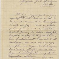
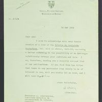
[Letter], 1935 Mar. 12, Berkeley, [to] Professor A. Quintanilha, Coimbra
University of Califórnia
Manuscrito
[Letter], 1935 Apr. 06, Montreal, [to A. Quintanilha], Coimbra
McGill University. Library; Clements, Th.
Manuscrito
[Letter], 1935 Mar. 12, Berkeley, [to] Professor A. Quintanilha, Coimbra
University of Califórnia. Library; MacIver, Ivander
Cartografia
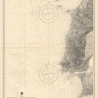
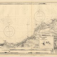
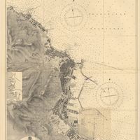
Spain : North Coast : Foz to Camariñas : from the spanish government charts of 1915 to 1920 : with additions and corrections to 1935
Edgell, J. A.
Cartografia
France : West Coast : La Gironde Royan to Bordeaux : from the french government chart of 1914 : with additions and corrections to 1954
Day, Archibald
Manuscrito
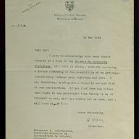
[Letter], 1934 Mar. 27, London, [to] Professor A. Quintanilha, Coimbra
British Museum (Natural History); Ramsbottom, J
Manuscrito
[Letter], 1934 May 15, Oxford, [to] Professor Dr. A. Quintanilha, Coimbra
Guiney, G.
Correspondência
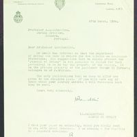
[Letter], 1934 May 16, Aberdeen, [to] Professor Dr. A. Quintanilha, Coimbra
Matthews, J. R
Manuscrito
[Letter], 1934 Dec. 7, New York, [to] Prof. Dr. A. Quintanilha, Coimbra
Howe, Marshall Avery
Manuscrito
[Letter], 1934 May 16, Aberdeen, [to] Professor Dr. A. Quintanilha, Coimbra
Matthews, J. R.
Correspondência
[Letter], 1934 Mar. 27, London, [to] Professor A. Quintanilha, Coimbra
British Museum (Natural History)
Correspondência
[Letter], 1934 May 15, Oxford, [to] Professor Dr. A. Quintanilha, Coimbra
Guiney, G
Cartografia
France West Coast Sheet VI : I. de Groix to Raz de Sein : from the French Government Charts of 1828 : with corrections to 1933
Washington, Capitão
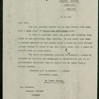
Correspondência
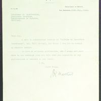
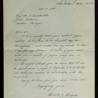
[Letter], 1933 Oct. 14, Jamaica Plain, [to] Professor Dr. A. Quintanilha, Coimbra
Faull, Joseph Horace
Manuscrito
[Letter], 1933 Oct. 10, Lincoln, [to] Dr. A. Quintanilha, Coimbra
Walker, Leva Belle
Manuscrito
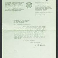
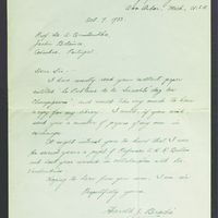
[Letter], 1933 Oct. 7, Ann Arbor, [to] Prof. Dr. A. Quintanilha, Coimbra
Brodie, Harold Johnston
Manuscrito
[Letter], 1933 Oct. 14, Jamaica Plain, [to] Professor Dr. A. Quintanilha, Coimbra
Faull, Joseph Horace
Correspondência
[Letter], 1933 Oct. 10, Lincoln, [to] Dr. A. Quintanilha, Coimbra
Walker, Leva Belle
Correspondência
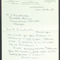
[Letter], 1933 Oct. 31, Ottawa, [to] Dr. A. Quintanilha, Coimbra
Mounce, Irene
Manuscrito
[Letter], 1933 Oct. 31, Ottawa, [to] Dr. A. Quintanilha, Coimbra
Mounce, Irene
Correspondência
[Letter], 1933 Oct. 7, Ann Arbor, [to] Prof. Dr. A. Quintanilha, Coimbra
Brodie, Harold Johnston
Cartografia
Mediterranean : Algeria : Algiers to C. Bougaroni : surveyed by Captain E. Mouchez of the french Navy 1867-9 : with corrections from the french gouvernment charts 1925-1926
Wharton, W. J. L.
Cartografia
Mediterranean : Algeria : Tunis : C. Bougaroni to Fratelli Rocks including Galita Channel
Richards, G. H.
Cartografia
Mediterranean Sea : Egypt : Damietta to El Arish
Douglas, H. P.
Manuscrito
[Letter], 1930 June 10, Lund, [to Luis Carrisso], Coimbra
Hässler, Arne
Manuscrito
[Letter], 1930 Sept. 2, Cambridge, [to Luís Carrisso], Coimbra
Manton, Irene
Cartografia
Mediterranean : Algeric : approaches to Bone : from french government chart 1889 : with corrections from the french government chart 1929
Wharton, W. J. L.
Manuscrito
[Letter], 1929 Jan. 26, London, [to] Dr. Carrisso, [Coimbra]
Rendle, Alfred Barton
Cartografia
France West Coast Sheet IV : Les Sables d'Olonne to Bourgneuf : from the Pilote Francais with corrections from French Government Charts to 1924
Washington, Capitão
Manuscrito
[Letter], 1925 Aug. 23, Harbin, [to Luís Carrisso], Coimbra
Manchúria Research Society; Skvortzow, B
Cartografia
Mediterranean Sea : Egypt : Alexandria to Port Saïd
Reyne, F. A.; Hill, S. A. G.; Douglas, H. P.
Manuscrito
[Letter], 1924, Felixtowe [to] Professor Carrisso, [Coimbra]
Giuseppi
Cartografia
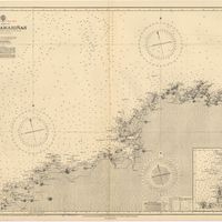
West coasts of Spain and Portugal : Cabo Villanno to Oporto : from the spanish and portuguese government charts to 1916 : with corrections and additions to 1921
Learmonth, Frederick C.
Manuscrito
[Letter], 1921 Mar. 01, The Herbarium, Royal Botanic Gardens, Kew, Surrey, [to Júlio Henriques, Coimbra]
Stapf, Otto
Manuscrito
[Letter], 1920 June 17, Syracuse, New York, [to] Y. Henriquet [sic] [Júlio Henriques], Coymbra[sic] [Coimbra]
Brown, Harry Philip
Manuscrito
[Letter], 1920 Sept. 08, Syracuse, New York, [to] J. a. Henriquez [sic] [Júlio Henriques], Coimbra
Brown, Harry Philip
Manuscrito
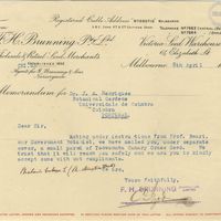
[Letter], 1920 Apr. 08, Melbourne, [to] J[úlio] A[ugusto] Henriques, Coimbra
F.H. Brunning Pty. Ltd
Cartografia
Portugal's Magnificent Roads now enable the travellers to make all excursions by car : Map of the international and other first-class roads connecting the principal tourist resorts, as ordered by the Commission of Tourism of the AUTOMOVEL CLUB DE PORTUGAL, Largo do Calhariz 29, Lisbon
Automóvel Club de Portugal. Comissão de turismo
Cartografia
France North Coast : Sheet VIII : Ushant to Plateau des Roches Douvres : from the pilote français 1823 : with additions and corrections to 1911
Wharton, W. J. L.
Manuscrito
[Letter], 1919 Nov. 01, Syracuse, New York, [to Júlio Henriques], Coimbra
Brown, Harry Philip
Manuscrito
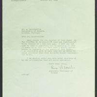
[Letter], 1919 Nov. 18, Kew, [to] J[úlio] A[ugusto] Henriques, Coimbra
Prain, David
Manuscrito
[Letter], 1919 Dec. 16, Syracuse, New York, [to] J[úlio] A[ugusto] Henriques, Coimbra
Brown, Harry Philip
Manuscrito
[Letter], 1919 July 29, Kew, [to] Prof. [Júlio] Henriques, Coimbra
Hill, Arthur William
Manuscrito
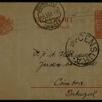
Brevkort, 1919 Mar. 18, Lund, [to] Dr. J. A. Henriques, Coimbra
Nordstedt, Carl Fredrik Otto
Manuscrito
[Letter], 1919 Mar. 12, Washington [to] J[úlio] A[ugusto] Yenrigues[sic], Coimbra
Morse, William Joseph
Manuscrito
[Letter], 1919 Mar. 25, Washington, [to] Mr. D. J. A. Yenriques enriques, Coimbra
Dorsett, Palemon Howard
Cartografia
France-North West Coast : Sheet VII : Raz de Sein to Goulven including Brest and Ushant : from French Government Charts to 1919
Washington, Capitão
Manuscrito
[Letter], 1917 July 19, Kew, [to] J[úlio] A[ugusto] Henriques, Coimbra
Prain, David
Manuscrito
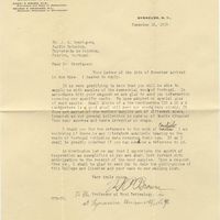
[Letter], 1917 July 31, Kew, [to] J[úlio] A[ugusto] Henriques, Coimbra
Prain, David