Os cookies.
Este site utiliza cookies para lhe proporcionar uma melhor experiência de utilização.
OK, ACEITO
Sobre
Itens da coleção
Refinar a pesquisa
Coleções digitais
Mapas Nabais Conde
Biblioteca Geral
11
Tipo
Cartografia
11
Autor
Day, A.
2
Day. A.
2
Wharton, W. J. L.
2
Day, Archibald
1
Edgell, J. A.
1
Ver mais
Data
1953-1954
Local de publicação
Londres
11
Assunto
Mapa
11
Mar Mediterrâneo
6
Argélia
3
Costa Ocidental
3
França
3
Ver mais
Idioma
Inglês
PT
EN
PT
EN
Biblioteca de Fundo Antigo da UC
Almamater
Em destaque
Todos os itens
Sobre
Nesta coleção
Pesquisa avançada
Refinar a pesquisa
Limpar
Coleções digitais
Mapas Nabais Conde
Biblioteca Geral
11
Tipo
Cartografia
11
Autor
Day, A.
2
Day. A.
2
Wharton, W. J. L.
2
Day, Archibald
1
Edgell, J. A.
1
Ver mais
Data
1953-1954
Local de publicação
Londres
11
Assunto
Mapa
11
Mar Mediterrâneo
6
Argélia
3
Costa Ocidental
3
França
3
Ver mais
Idioma
Inglês
Itens
11
Ver como
Galeria
Lista
Grelha
Ordenar por
Título (descendente)
Título
Data (de publicação)
Data (descendente)
Limite por página
50
100
250
Cartografia
Spain : South Coast : Pta. del Acebuche to Pta. de la Chullera including Gibraltar Bay : from the spanish government charts of 1872-1914
Cartografia
Mediterranean Sea : plans of the Coast of Libya : Rada and Porto di Tripoli : from the italian Gouvernment chart of 1930
Cartografia
Mediterranean Sea : Egypt : approaches to Port Said ; Port Said
Cartografia
Mediterranean Sea : Algérie : C. Ferrat to C. Bougaroni : from the french government surveys of 1868-74 : the coast of Spain from spanish authorities
Cartografia
Mediterranean : Gibraltar : surveyed by Capt. R. M. Southern R. N. and officers of H. M. Surveying ship "Challenger" : 1947-1948
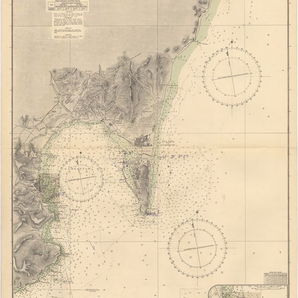
Cartografia
Mediterranean : Algérie : C. Ivi to Alger : from the french government charts of 1867-1870 : with additions and corrections to 1951
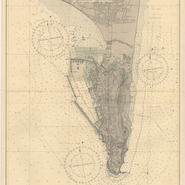
Cartografia
Mediterranean : Algeria : Ports d'Oran and Mers-el-Kébir : from the french government chart of 1876 : with corrections to 1953
Cartografia
France West Coast : La Loire St. Nazaire to Nantes : from French Government Charts to 1948 : with corrections to 1948
Cartografia
France West Coast : entrance to La Loire and approaches to St. Nazaire : from the French Government Charts of 1893 : with corrections to 1954
Cartografia
France : West Coast : Pertuis d'Antioche with the approaches to La Rochelle and Rochefort : from the latest french government charts to 1950 : with additions and corrections to 1953
Cartografia
Bay of Biscay : from the latest information in the hydrographic Dept. to 1953