Os cookies.
Este site utiliza cookies para lhe proporcionar uma melhor experiência de utilização.
OK, ACEITO
Sobre
Itens da coleção
Refinar a pesquisa
Coleções digitais
Biblioteca Geral
22
Mapas Nabais Conde
21
EU
1
Tipo
Cartografia
17
Gravuras e Desenhos
4
Livro Antigo
1
Autor
Gibson, John
3
Kitchin, Thomas,
2
Alagna, J. Giacomo
1
Cole, Benjamin
1
Congreve, William
1
Ver mais
Data
1752-1783
Local de publicação
Londres
22
Assunto
Açores
5
Lisboa
5
Mapa
5
Portugal
5
Iconografia
4
Ver mais
Idioma
Inglês
PT
EN
PT
EN
Biblioteca de Fundo Antigo da UC
Almamater
Em destaque
Todos os itens
Sobre
Nesta coleção
Pesquisa avançada
Refinar a pesquisa
Limpar
Coleções digitais
Biblioteca Geral
22
Mapas Nabais Conde
21
EU
1
Tipo
Cartografia
17
Gravuras e Desenhos
4
Livro Antigo
1
Autor
Gibson, John
3
Kitchin, Thomas,
2
Alagna, J. Giacomo
1
Cole, Benjamin
1
Congreve, William
1
Ver mais
Data
1752-1783
Local de publicação
Londres
22
Assunto
Açores
5
Lisboa
5
Mapa
5
Portugal
5
Iconografia
4
Ver mais
Idioma
Inglês
Itens
22
Ver como
Grelha
Lista
Galeria
Ordenar por
Data (descendente)
Título
Título (descendente)
Data (de publicação)
Limite por página
50
100
250
Cartografia
Various charts of islands &c., in the Atlantic & Pacific Oceans
Millar, George Henry
Gravuras e Desenhos
A general view of Lisbon, the capital city of Portugal
Cartografia
Bowles's new pocket map of Portugal
Nolin, Jean Baptiste
Cartografia
Map of South America : For the Ver. Dr. Robertson's History of America
Cartografia
A Chart of the Maderas and Canary Islands : from the Draughts and Memoirs of Captn. George Glas : Regulated and Ascertained by Astronomical Observations.
Cartografia
Chart of the Açores (Hawks) Islands, called also Flemish and Western Islands.
Cartografia
Spain and Portugal
Kitchin, Thomas,
Livro Antigo
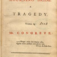
The mourning bride : a tragedy
Congreve, William
Cartografia
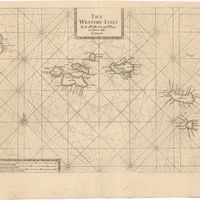
The Western Isles
Cartografia
The Western Isles
Cartografia
A new and correct chart of the coast of Portugal from Cape Stan to Cape Montego ; A new and correct chart of the coast of Portugal from Cape Montego to Pont de Faro
Cartografia
A map of the Kingdom of Portugal
Cartografia
Portugal
Gravuras e Desenhos
A general view of the city of Lisbon, the capital of the Kingdom of Portugal as it stood on the North side of the river Tagus or Tajo before the late earthquakes, on November 1.st & 8.th 1755
Cartografia
The theatre of war in Portugal with the distances of the fortified towns, from Lisbon
Cartografia
A Map of the River Tale to Lisbon Done from a New Survey
Cartografia
A chart of the sea coasts of Algrave [sic] and Andalusia between cape St. Vincent and the strait of Gibralter and c. Spartel
Gravuras e Desenhos
Ruins of Lisbon after the Earth-Quake on the 1st. Nov.br 1755 : The Opera House
Cartografia
A plan of the city of Lisbon with the Harbour, Forts, Depth of Water and Country adjacent : for the Lond. Mag.
Cartografia
Spain and Portugal. A map of the mouth of the River Tagus or harbour of the city of Lisbon
Cartografia
A Chart of the Açores (Hawks) Islands, called also Flemish and Western Islands from Mr. D'Anviille with several additions.
Gravuras e Desenhos
A view of the Palace of the King of Portugal at Lisbone = Vüe de Palais Roi de Portugale à Lisbon