Os cookies.
Este site utiliza cookies para lhe proporcionar uma melhor experiência de utilização.
OK, ACEITO
Sobre
Itens da coleção
Refinar a pesquisa
Coleções digitais
Biblioteca Geral
15
Mapas Nabais Conde
15
Botânica
1
Tipo
Cartografia
15
Manuscrito
1
Autor
Elliott, Wm, Capt.
3
Neele, Samuel John
3
Nantiat, Jasper
2
Arrowsmith, Aaron
1
Ball, John
1
Ver mais
Data
1797-1810
Local de publicação
Londres
Assunto
Portugal
8
Mapa
7
Peninsula Ibérica
2
Açores
1
Carta militar
1
Ver mais
Idioma
Inglês
13
Português
2
Francês
1
PT
EN
PT
EN
Biblioteca de Fundo Antigo da UC
Almamater
Em destaque
Todos os itens
Sobre
Nesta coleção
Pesquisa avançada
Refinar a pesquisa
Limpar
Coleções digitais
Biblioteca Geral
15
Mapas Nabais Conde
15
Botânica
1
Tipo
Cartografia
15
Manuscrito
1
Autor
Elliott, Wm, Capt.
3
Neele, Samuel John
3
Nantiat, Jasper
2
Arrowsmith, Aaron
1
Ball, John
1
Ver mais
Data
1797-1810
Local de publicação
Londres
Assunto
Portugal
8
Mapa
7
Peninsula Ibérica
2
Açores
1
Carta militar
1
Ver mais
Idioma
Inglês
13
Português
2
Francês
1
Itens
16
Ver como
Galeria
Lista
Grelha
Ordenar por
Título (descendente)
Título
Data (de publicação)
Data (descendente)
Limite por página
50
100
250
Cartografia
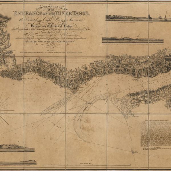
A topographical chart of the entrance of the river Tagus, describing the coast from Cape Roca to Sacavem ; with the harbour and environs of Lisbon. The nautical part is from a survey taken in 1806 by W. Chapman, Master of the Royal Navy; and approved by the Chart Committee of the Admiralty. The interior and line of the coast are drawn from survays made by officers of the Quarter Master General's Department
Cartografia
Portugal including Algarve
Cartografia
Portugal
Cartografia
Portugal
Cartografia
Physical Map of the Island of Madeira
Cartografia
A new military map of Portugal : the roads from the Carta militar published by the french in Lisbon, the rivers and montains, from the best authorities
Cartografia
A new military map of Portugal : the roads from the Carta Militar published by the french in Lisbon : the rivers and mountains from the last Authorities
Cartografia
A new military map of Portugal : the roads from the Carta Militar published by the french in Lisbon : the rivers and mountains from the last Authorities
Cartografia
A new map of the Kingdom of Portugal divided into its provinces
Cartografia
A new map of Spain and Portugal : exhibiting the chains of mountains with their passes, the principal & cross roads, with other details requisite for the intelligence of Military Operations
Cartografia
A new map of Spain and Portugal : exhibiting the chains of mountains with their passes, the principal & cross roads, with other details requisite for the intelligence of Military Operations
Cartografia
A Military sketch of the country between Lisbon and Vimiero occupied by the British Army under the command of Lieutenant General Viscount Wellington
Manuscrito
[Lettre, 18--] juin. 24, London, [à Júlio Henriques, Coimbra]
Cartografia
Chorographical map of the kingdom of Portugal divided into its grand provincies = Mappa corografico do Reino de Portugal
Cartografia
Chart of the Island of St. Michael
Cartografia
Chart of the Açores (Hawks) Islands, called also Flemish and Western Islands.