Os cookies.
Este site utiliza cookies para lhe proporcionar uma melhor experiência de utilização.
OK, ACEITO
Sobre
Itens da coleção
Refinar a pesquisa
Coleções digitais
Biblioteca Geral
Mapas Nabais Conde
76
Tipo
Cartografia
76
Autor
Edgell, J. A.
8
Wharton, W. J. L.
7
Walker, J. & C.
6
Day, A.
4
Douglas, H. P.
4
Ver mais
Data
1954
6
1953
5
1810
5
1780-1809
6
1626-1750
4
Ver mais
Local de publicação
Londres
Dublin
1
Edimburgo
1
Assunto
Mapa
Mar Mediterrâneo
28
Portugal
15
Costa Ocidental
12
França
12
Ver mais
Idioma
Inglês
73
Português
3
PT
EN
PT
EN
Biblioteca de Fundo Antigo da UC
Almamater
Em destaque
Todos os itens
Sobre
Nesta coleção
Pesquisa avançada
Refinar a pesquisa
Limpar
Coleções digitais
Biblioteca Geral
Mapas Nabais Conde
76
Tipo
Cartografia
76
Autor
Edgell, J. A.
8
Wharton, W. J. L.
7
Walker, J. & C.
6
Day, A.
4
Douglas, H. P.
4
Ver mais
Data
1954
6
1953
5
1810
5
1780-1809
6
1626-1750
4
Ver mais
Local de publicação
Londres
Dublin
1
Edimburgo
1
Assunto
Mapa
Mar Mediterrâneo
28
Portugal
15
Costa Ocidental
12
França
12
Ver mais
Idioma
Inglês
73
Português
3
Itens
76
Ver como
Grelha
Lista
Galeria
Ordenar por
Data (descendente)
Título
Título (descendente)
Data (de publicação)
Limite por página
50
100
250
Cartografia
Mediterranean Sea : Tunisia : East Coast : Kélibia to Tripoli : principally from french and italian Gouvernment charts to 1954
Collins, K. St. B.
Cartografia
Mediterranean : Tunisia : North Coast : Lac de Bizerte and Entrance : from french government charts to 1948 : with corrections to 1957
Edgell, J. A.
Cartografia
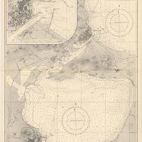
Mediterranean Sea : Tunisia : East Coast : approaches to Sfax : from the french Gouvernment charts to 1952 : with corrections to 1953
Collins, K. St. B.
Cartografia
Mediterranean Sea : Marocco : Bahia de Ceuta : from the Spanish Gouvernment Chart of 1926 : with corrections to 1956
Douglas, H. P.
Cartografia
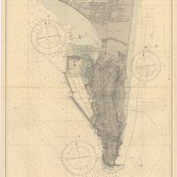
Mediterranean Sea : Egypt : Alexandria Harbour
Hardy, N. A. C.; Day, A.; Edgell, J. A.
Cartografia
Mediterranean : Tunisia : Baie de Tunis : from the french Gouvernment charts of 1893 : with corrections to 1953
Day, A.
Cartografia
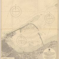
Mediterranean : Libya : Porto di Tripoli
Wyatt, Guy
Cartografia
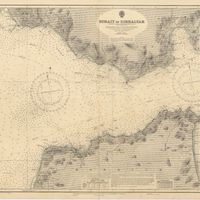
Strait of Gibraltar : from the spanish government charts of 1936 : with corrections to 1953
Edgell, J. A.
Cartografia
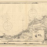
France : West Coast : Entrance to La Gironde : from the french government charts of 1887 : with additions and corrections to 1955
Wharton, W. J. L.
Cartografia
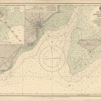
Mediterranean Sea : Egypt : approaches to Port Said ; Port Said
Day, Archibald
Cartografia
Mediterranean Sea : plans of the Coast of Libya : Rada and Porto di Tripoli : from the italian Gouvernment chart of 1930
Parry, J. F.
Cartografia
Spain : South Coast : Pta. del Acebuche to Pta. de la Chullera including Gibraltar Bay : from the spanish government charts of 1872-1914
Mostyn, A.
Cartografia
France West Coast : entrance to La Loire and approaches to St. Nazaire : from the French Government Charts of 1893 : with corrections to 1954
Wharton, W. J. L.
Cartografia
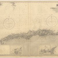
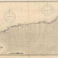
Mediterranean Sea : Algérie : C. Ferrat to C. Bougaroni : from the french government surveys of 1868-74 : the coast of Spain from spanish authorities
Richards, G. H.
Cartografia
Mediterranean : Algérie : C. Ivi to Alger : from the french government charts of 1867-1870 : with additions and corrections to 1951
Wharton, W. J. L.
Cartografia
Mediterranean : Gibraltar : surveyed by Capt. R. M. Southern R. N. and officers of H. M. Surveying ship "Challenger" : 1947-1948
Day, A.
Cartografia
Bay of Biscay : from the latest information in the hydrographic Dept. to 1953
Day, A.
Cartografia
France West Coast : La Loire St. Nazaire to Nantes : from French Government Charts to 1948 : with corrections to 1948
Day. A.
Cartografia
France : West Coast : Pertuis d'Antioche with the approaches to La Rochelle and Rochefort : from the latest french government charts to 1950 : with additions and corrections to 1953
Day. A.
Cartografia
Mediterranean : Algeria : Ports d'Oran and Mers-el-Kébir : from the french government chart of 1876 : with corrections to 1953
Edgell, J. A.
Cartografia
Mediterranean : Africa : C. Tres Forcas to C. Ivi : surveyed by Captain E. Mouchez of the french Navy 1870-73
Wharton, W. J. L.
Cartografia
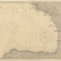
Cape St. Vincent to the Strait of Gibraltar : compiled from the latest government charts
Mostyn, A.
Cartografia
Mediterranean : Israel : Bay of Acre ; Acre Anchorage ; Haifa Harbour
Douglas, H. P.; Edgell, J. A.
Cartografia
France West Coast Sheet V : Bourgneuf to I. de Groix : from the Pilote Francais with corrections from French Government Charts to 1949
Washington, Capitão
Cartografia
France West Coast Sheet III : Pte. de la Coubre to les Sables d'Olonne : from the French Government Charts to 1940
Edgell, John
Cartografia
Mediterranean Sea : Algeria : approaches to Alger : from the french government charts to 1932 : with corrections to 1950
Edgell, John
Cartografia
France West Coast : Ile d'Ouessant to St. Nazaire : from the French Government Charts to 1939
Edgell, John
Cartografia
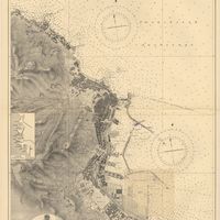
Mediterranean Sea : Algeria : Port d'Alger : from the french government chart of 1911 : with corrections to 1938
Purey-Cust, H. E.
Cartografia
Mediterranean Sea : Libya : Ras Ashdir to Sirte : from the italian Gouvernment charts of 1931-32
Edgell, J. A.
Cartografia
Mediterranean : Coast of Palestine : Tyre to El Arish
Edgell, J. A.
Cartografia
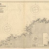
Spain : North Coast : Foz to Camariñas : from the spanish government charts of 1915 to 1920 : with additions and corrections to 1935
Edgell, J. A.
Cartografia
France : West Coast : La Gironde Royan to Bordeaux : from the french government chart of 1914 : with additions and corrections to 1954
Day, Archibald
Cartografia
France West Coast Sheet VI : I. de Groix to Raz de Sein : from the French Government Charts of 1828 : with corrections to 1933
Washington, Capitão
Cartografia
Mediterranean : Algeria : Algiers to C. Bougaroni : surveyed by Captain E. Mouchez of the french Navy 1867-9 : with corrections from the french gouvernment charts 1925-1926
Wharton, W. J. L.
Cartografia
Mediterranean : Algeria : Tunis : C. Bougaroni to Fratelli Rocks including Galita Channel
Richards, G. H.
Cartografia
Mediterranean Sea : Egypt : Damietta to El Arish
Douglas, H. P.
Cartografia
Mediterranean : Algeric : approaches to Bone : from french government chart 1889 : with corrections from the french government chart 1929
Wharton, W. J. L.
Cartografia
France West Coast Sheet IV : Les Sables d'Olonne to Bourgneuf : from the Pilote Francais with corrections from French Government Charts to 1924
Washington, Capitão
Cartografia
Mediterranean Sea : Egypt : Alexandria to Port Saïd
Reyne, F. A.; Hill, S. A. G.; Douglas, H. P.
Cartografia
France North Coast : Sheet VIII : Ushant to Plateau des Roches Douvres : from the pilote français 1823 : with additions and corrections to 1911
Wharton, W. J. L.
Cartografia
France-North West Coast : Sheet VII : Raz de Sein to Goulven including Brest and Ushant : from French Government Charts to 1919
Washington, Capitão
Cartografia
Mediterranean Sea : Europe Gibraltar to Alicante : Africa Cape Spartel to Cape Ferrat : from spanish and french government charts to 1877
Evans, F. J.
Cartografia
Portugal : Nº 4
Cartografia
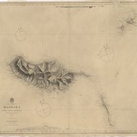
The islands of Madeira, Porto santo and Dezertas
Vidal, Alexander Thomas Emeric
Cartografia
Mediterranean : Tunis : Fratelli Rocks to Mahedia
Richards, G. H.; Boyle, A. J.
Cartografia
Portuguese Islands in the Atlantic Ocean
Cartografia
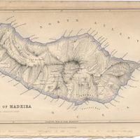
Island of Madeira
Cartografia
Map of the wine district of the Alto-Douro
Forrester, Joseph James
Cartografia
The Delta of the River Kowara or Quorra, the ancient Niger
McQueen, James
Cartografia
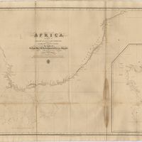
West Coast of Africa : Sheet VI : Cape Verde to Cape Roxo including the Gambia
Boteler, T.
Cartografia
Africa : Sheet II : from the River Gambia to cape Lopez and Annabona including the Bight of Biafra
De Mayne, Anthony; Owen, William Fitzwilliam; Vidal, Alexander Thomas Emeric
Cartografia
Map of Portugal
Arrowsmith, Aaron
Cartografia
Africa : Sheet V : from Cape Corrientes to Juba Islands including Madagascar, Comoro, Zanzibar, Ids. & c.
Owen, William Fitzwilliam
Cartografia
Spain and Portugal
Cartografia
Africa : Sheet IV : from Hollams Island to Cape Corrientes including the Cape of Good Hope
Owen, William Fitzwilliam
Cartografia
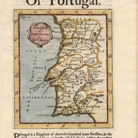
Portugal
Cartografia
A new map of the kingdoms of Spain and Portugal with their principals divisions.
Cartografia
A new military map of Portugal : the roads from the Carta Militar published by the french in Lisbon : the rivers and mountains from the last Authorities
Elliott, Wm, Capt.
Cartografia
A new military map of Portugal : the roads from the Carta militar published by the french in Lisbon, the rivers and montains, from the best authorities
Elliott, Wm, Capt.
Cartografia
A new military map of Portugal : the roads from the Carta Militar published by the french in Lisbon : the rivers and mountains from the last Authorities
Elliott, Wm, Capt.
Cartografia
A new map of Spain and Portugal : exhibiting the chains of mountains with their passes, the principal & cross roads, with other details requisite for the intelligence of Military Operations
Nantiat, Jasper
Cartografia
A new map of Spain and Portugal : exhibiting the chains of mountains with their passes, the principal & cross roads, with other details requisite for the intelligence of Military Operations
Nantiat, Jasper
Cartografia
Portugal including Algarve
Tofinõ de San Miguel, Vicente; López de Vargas Machuca, Tomás
Cartografia
Chorographical map of the kingdom of Portugal divided into its grand provincies = Mappa corografico do Reino de Portugal
Faden, William
Cartografia
The Kingdoms of Portugal and Algarve from Zannonïs Map
Rizzi-Zannoni,Giovanni Antonio
Cartografia
Mappa ou carta geographica dos reinos de Portugal e Algarve
Faden, William
Cartografia
The Kingdoms of Portugal and Algarve from Zannonïs Map
Rizzi-Zannoni,Giovanni Antonio
Cartografia
Bowles's new pocket map of Portugal
Nolin, Jean Baptiste
Cartografia
Map of South America : For the Ver. Dr. Robertson's History of America
Cartografia
Spain and Portugal
Kitchin, Thomas,
Cartografia
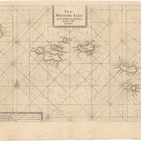
The Western Isles
Cartografia
The Western Isles
Cartografia
Azores
Torfino de San Miguel, Vincente; Claret de Fleurieu, Charles Pierre
Cartografia
Island of Madera ; The Dragon Tree
Cartografia
A new map of Portugal
Cartografia
Spaine newly described with many adictions, both in the attires of the people & the setuations of their cheifest cityes
Speed, John