Os cookies.
Este site utiliza cookies para lhe proporcionar uma melhor experiência de utilização.
OK, ACEITO
Sobre
Itens da coleção
Refinar a pesquisa
Coleções digitais
Biblioteca Geral
Mapas Nabais Conde
141
500 Anos da Biblioteca
1
EU
1
Tipo
Cartografia
131
Gravuras e Desenhos
10
Livro Antigo
2
Autor
Walker, J. & C.
17
Vidal, Alexander Thomas Emeric
11
Owen, William Fitzwilliam
10
Edgell, J. A.
8
Wharton, W. J. L.
8
Ver mais
Data
1842-1865
10
1839-1841
9
1787-1809
9
1766-1783
8
1758-1764
9
Ver mais
Local de publicação
Londres
Nova Iorque
2
Dublin
1
Edimburgo
1
Assunto
Mapa
73
Portugal
33
Mar Mediterrâneo
28
Costa Ocidental
23
Oceano Atlântico
23
Ver mais
Idioma
Inglês
PT
EN
PT
EN
Biblioteca de Fundo Antigo da UC
Almamater
Em destaque
Todos os itens
Sobre
Nesta coleção
Pesquisa avançada
Refinar a pesquisa
Limpar
Coleções digitais
Biblioteca Geral
Mapas Nabais Conde
141
500 Anos da Biblioteca
1
EU
1
Tipo
Cartografia
131
Gravuras e Desenhos
10
Livro Antigo
2
Autor
Walker, J. & C.
17
Vidal, Alexander Thomas Emeric
11
Owen, William Fitzwilliam
10
Edgell, J. A.
8
Wharton, W. J. L.
8
Ver mais
Data
1842-1865
10
1839-1841
9
1787-1809
9
1766-1783
8
1758-1764
9
Ver mais
Local de publicação
Londres
Nova Iorque
2
Dublin
1
Edimburgo
1
Assunto
Mapa
73
Portugal
33
Mar Mediterrâneo
28
Costa Ocidental
23
Oceano Atlântico
23
Ver mais
Idioma
Inglês
Itens
143
Ver como
Grelha
Lista
Galeria
Ordenar por
Data (de publicação)
Título
Título (descendente)
Data (descendente)
Páginas
1
2
3
Limite por página
50
100
250
Cartografia
Spaine newly described with many adictions, both in the attires of the people & the setuations of their cheifest cityes
Speed, John
Cartografia
A chart of Spaine : perticulerly discribing the coasts of Biscaia Gallissia Portugal Andaluzia Granada Ec
Seller, John
Cartografia
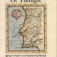
A new map of Portugal
Cartografia
The Coast of Portugal from River de Sinis to Siluis ; The coast of Andalousie from Siluis to Pallos.
Cartografia
A new map of Iberia Europaea alias Celtiberia, or Ancient Spain : shewing its principal divisions, cheif cities, townes, rivers, mountains & c[?]. Dedicated to His Highness William Duke of Gloucester
Wells, Edward
Cartografia
A new map of present Spain & Portugal : shewing their principal divisions, cheif cities, townes, rivers, mountains & c. : Dedicated to His Highness William Duke of Gloucester
Wells, Edward
Cartografia
A correct map of Spain & Portugal : according to the newest observations and discoveries comunicated to the Royal Society at London and the Royal Academy at Paris is humbly dedicated to the Right Honorable Iohn Ld. Somers Baron of Evesham
Cartografia
Spain and Portugal
Cartografia
Portugal : agreeable to modern history
Moll, Herman
Cartografia
A new and accurate map of Spain and Portugal : drawn from the best Authorities
Bowen, Thomas
Livro Antigo
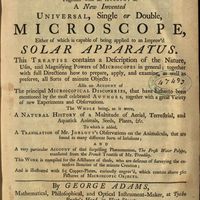
Micrographia illustrata, or, The knowledge of the microscope explain'd together with an account of a New Invented Universal, single or double, Microscope, either of which is capable of being applied to an Improv'd Solar Apparatus. This Treatise contains a Description of the Nature, Uses, and Magnifysing Powers of Microscopes in general; together with full Directions how to prepare, apply, and examine, as well as preserve, all Sorts of minute Objects also an account of The principal Microcopical Discoveries, that have hirherto been mentioned by the most celebrated Authors, togeher with a great Variety of new Experiments and Observations. The whole being, as it were, A Natural History of a Multitude of Aerial, Terrestrial, and Aquatick Animals, Seeds, Plants, Etc. To which is added, A Translation of Mr. Joblott's Observations on the Animalcula, that are found in many different Sorts of Infusions and a very particular Account of the surprising Phaenomenon, The Fresh Water Polype, translated from the French Treatise of Mr. Trembley. This Work is compiled for the Assistance of those, who are desirous of surveyng the extensive Beauties of the minute Creation and is illustreted with 65 Copper-plates, curiously engrav'd, wich contain above 560 Pictures of Microscopic Objets
Adams, George; Trembley, Abraham
Cartografia
A new and accurate map of Portugal : composed from the latest improvem.ts and adjusted by the most authentic astron. observats.
Cartografia
Island of Madera ; The Dragon Tree
Gravuras e Desenhos
A view of the Palace of the King of Portugal at Lisbone = Vüe de Palais Roi de Portugale à Lisbon
Cartografia
A Chart of the Açores (Hawks) Islands, called also Flemish and Western Islands from Mr. D'Anviille with several additions.
Cartografia
A plan of the city of Lisbon with the Harbour, Forts, Depth of Water and Country adjacent : for the Lond. Mag.
Cartografia
Spain and Portugal. A map of the mouth of the River Tagus or harbour of the city of Lisbon
Gravuras e Desenhos
Ruins of Lisbon after the Earth-Quake on the 1st. Nov.br 1755 : The Opera House
Cartografia
A Map of the River Tale to Lisbon Done from a New Survey
Cartografia
A chart of the sea coasts of Algrave [sic] and Andalusia between cape St. Vincent and the strait of Gibralter and c. Spartel
Gravuras e Desenhos
A general view of the city of Lisbon, the capital of the Kingdom of Portugal as it stood on the North side of the river Tagus or Tajo before the late earthquakes, on November 1.st & 8.th 1755
Cartografia
The theatre of war in Portugal with the distances of the fortified towns, from Lisbon
Cartografia
Portugal
Cartografia
A map of the Kingdom of Portugal
Cartografia
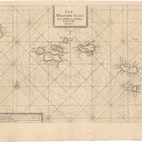
The Western Isles
Cartografia
The Western Isles
Cartografia
A new and correct chart of the coast of Portugal from Cape Stan to Cape Montego ; A new and correct chart of the coast of Portugal from Cape Montego to Pont de Faro
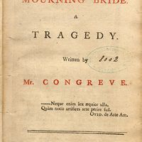
Livro Antigo
The mourning bride : a tragedy
Congreve, William
Cartografia
Spain and Portugal
Kitchin, Thomas,
Cartografia
Chart of the Açores (Hawks) Islands, called also Flemish and Western Islands.
Cartografia
A Chart of the Maderas and Canary Islands : from the Draughts and Memoirs of Captn. George Glas : Regulated and Ascertained by Astronomical Observations.
Cartografia
Map of South America : For the Ver. Dr. Robertson's History of America
Cartografia
Bowles's new pocket map of Portugal
Nolin, Jean Baptiste
Gravuras e Desenhos
A general view of Lisbon, the capital city of Portugal
Cartografia
Various charts of islands &c., in the Atlantic & Pacific Oceans
Millar, George Henry
Cartografia
The Kingdoms of Portugal and Algarve from Zannonïs Map
Rizzi-Zannoni,Giovanni Antonio
Cartografia
The Kingdoms of Portugal and Algarve from Zannonïs Map
Rizzi-Zannoni,Giovanni Antonio
Cartografia
Chart of the Açores (Hawks) Islands, called also Flemish and Western Islands.
Cartografia
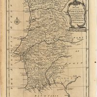
Chorographical map of the kingdom of Portugal divided into its grand provincies = Mappa corografico do Reino de Portugal
Faden, William
Cartografia
A new map of the Kingdom of Portugal divided into its provinces
Cartografia
Portugal
Arrowsmith, Aaron
Cartografia
Portugal
Cartografia
Chart of the Island of St. Michael
Read, W. Harding
Cartografia
Portugal including Algarve
Tofinõ de San Miguel, Vicente; López de Vargas Machuca, Tomás
Cartografia
A new military map of Portugal : the roads from the Carta Militar published by the french in Lisbon : the rivers and mountains from the last Authorities
Elliott, Wm, Capt.
Cartografia
A new military map of Portugal : the roads from the Carta militar published by the french in Lisbon, the rivers and montains, from the best authorities
Elliott, Wm, Capt.
Cartografia
A topographical chart of the entrance of the river Tagus, describing the coast from Cape Roca to Sacavem ; with the harbour and environs of Lisbon. The nautical part is from a survey taken in 1806 by W. Chapman, Master of the Royal Navy; and approved by the Chart Committee of the Admiralty. The interior and line of the coast are drawn from survays made by officers of the Quarter Master General's Department
Chapman, William
Cartografia
A new map of Spain and Portugal : exhibiting the chains of mountains with their passes, the principal & cross roads, with other details requisite for the intelligence of Military Operations
Nantiat, Jasper
Cartografia
A new map of Spain and Portugal : exhibiting the chains of mountains with their passes, the principal & cross roads, with other details requisite for the intelligence of Military Operations
Nantiat, Jasper
Cartografia
A Military sketch of the country between Lisbon and Vimiero occupied by the British Army under the command of Lieutenant General Viscount Wellington