Os cookies.
Este site utiliza cookies para lhe proporcionar uma melhor experiência de utilização.
OK, ACEITO
Sobre
Itens da coleção
Refinar a pesquisa
Coleções digitais
Biblioteca Geral
41
Mapas Nabais Conde
41
Botânica
20
Tipo
Cartografia
41
Manuscrito
19
Correspondência
1
Autor
Stapf, Otto
10
Wharton, W. J. L.
7
Edgell, J. A.
5
Day, A.
4
Richards, G. H.
4
Ver mais
Data
1955
1954
1953
1911-1912
1908-1910
Ver mais
Local de publicação
Londres
Assunto
Mapa
36
Mar Mediterrâneo
22
Plantas
14
Costa Ocidental
12
França
11
Ver mais
Idioma
Inglês
49
Francês
9
Português
3
PT
EN
PT
EN
Biblioteca de Fundo Antigo da UC
Almamater
Em destaque
Todos os itens
Sobre
Nesta coleção
Pesquisa avançada
Refinar a pesquisa
Limpar
Coleções digitais
Biblioteca Geral
41
Mapas Nabais Conde
41
Botânica
20
Tipo
Cartografia
41
Manuscrito
19
Correspondência
1
Autor
Stapf, Otto
10
Wharton, W. J. L.
7
Edgell, J. A.
5
Day, A.
4
Richards, G. H.
4
Ver mais
Data
1955
1954
1953
1911-1912
1908-1910
Ver mais
Local de publicação
Londres
Assunto
Mapa
36
Mar Mediterrâneo
22
Plantas
14
Costa Ocidental
12
França
11
Ver mais
Idioma
Inglês
49
Francês
9
Português
3
Itens
61
Ver como
Grelha
Lista
Galeria
Ordenar por
Título
Título (descendente)
Data (de publicação)
Data (descendente)
Limite por página
50
100
250
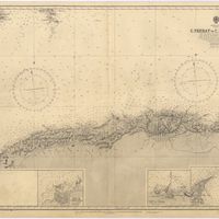
Cartografia
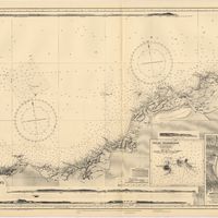
Bay of Biscay : from the latest information in the hydrographic Dept. to 1953
Day, A.
Manuscrito
[Carta, 1910? Dez.?] Londres, [a Júlio Henriques, Coimbra]
Gossweiler, John
Manuscrito
[Carta], 1910, Dez. 15, Londres, [a Júlio Henriques, Coimbra]
Gossweiler, John
Manuscrito
[Carta], 1934 Nov. 21, Londres [a] Presidente da Assembleia Geral da Junta de Educação Nacional, [Lisboa]
Costa, A. Celestino da
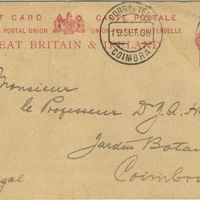
Manuscrito
[Carte Postale], 1908 sept. 16, Royal Gardens Kew, [Londres], [à] J.[úlio] A. Henriques, Coimbra
Stapf, Otto
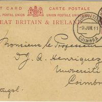
Manuscrito
[Carte Postale], 1911 juin 05, Royal Gardens Kew, [Londres], [à] J.[úlio] A. Henriques, Coimbra
Stapf, Otto
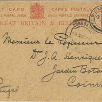
Manuscrito
[Carte Postale], 1914 avr. 30, Royal Gardens Kew, [Londres], [à] J.[úlio] A. Henriques, Coimbra
Stapf, Otto
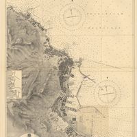
Cartografia
France : West Coast : Entrance to La Gironde : from the french government charts of 1887 : with additions and corrections to 1955
Wharton, W. J. L.
Cartografia
France : West Coast : La Gironde Royan to Bordeaux : from the french government chart of 1914 : with additions and corrections to 1954
Day, Archibald
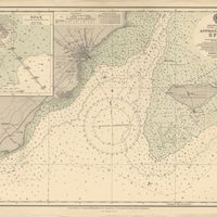
Cartografia
France : West Coast : Pertuis d'Antioche with the approaches to La Rochelle and Rochefort : from the latest french government charts to 1950 : with additions and corrections to 1953
Day. A.
Cartografia
France West Coast : entrance to La Loire and approaches to St. Nazaire : from the French Government Charts of 1893 : with corrections to 1954
Wharton, W. J. L.
Cartografia
France West Coast : Ile d'Ouessant to St. Nazaire : from the French Government Charts to 1939
Edgell, John
Cartografia
France West Coast : La Loire St. Nazaire to Nantes : from French Government Charts to 1948 : with corrections to 1948
Day. A.
Cartografia
France West Coast Sheet III : Pte. de la Coubre to les Sables d'Olonne : from the French Government Charts to 1940
Edgell, John
Cartografia
France West Coast Sheet IV : Les Sables d'Olonne to Bourgneuf : from the Pilote Francais with corrections from French Government Charts to 1924
Washington, Capitão
Cartografia
France West Coast Sheet V : Bourgneuf to I. de Groix : from the Pilote Francais with corrections from French Government Charts to 1949
Washington, Capitão
Cartografia
France West Coast Sheet VI : I. de Groix to Raz de Sein : from the French Government Charts of 1828 : with corrections to 1933
Washington, Capitão
Cartografia
France-North West Coast : Sheet VII : Raz de Sein to Goulven including Brest and Ushant : from French Government Charts to 1919
Washington, Capitão
Manuscrito
[Letter], 1911 Mar. 11, Kew, [to] Dr. J. A. Henriques, Coimbra
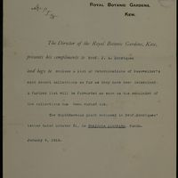
Royal Botanic Gardens, Kew
Manuscrito
[Letter], 1912 Oct. 3, Kew, [to] Prof. J. A. Henriques, Coimbra
Royal Botanic Gardens, Kew
Manuscrito
[Letter], 1915 Jan. 4, Kew, [to] Prof. J. A. Henriques, Coimbra
Royal Botanic Gardens, Kew
Manuscrito
[Letter], 1916 Oct. 25, Kew, [to] Monsieur le Prof. J. Henriques, Coimbra
Royal Botanic Gardens, Kew
Manuscrito
[Letter], 1916 Sep. 18, [Kew, Londres], [to] J.[úlio] A. Henriques, [Coimbra]
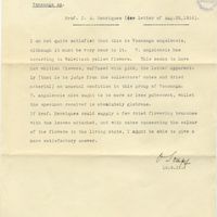
Stapf, Otto
Manuscrito
[Letter], 1917 July 14, Herbarium, Royal Botanic Gardens, Kew, [Londres], [to Júlio] Henriques, [Coimbra]
Stapf, Otto
Manuscrito
[Letter], 1921 Mar. 01, The Herbarium, Royal Botanic Gardens, Kew, Surrey, [to Júlio Henriques, Coimbra]
Stapf, Otto
Manuscrito
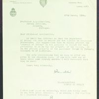
[Letter], 1929 Jan. 26, London, [to] Dr. Carrisso, [Coimbra]
Rendle, Alfred Barton
Manuscrito
[Letter], 1934 Mar. 27, London, [to] Professor A. Quintanilha, Coimbra
British Museum (Natural History); Ramsbottom, J
Correspondência
[Letter], 1934 Mar. 27, London, [to] Professor A. Quintanilha, Coimbra
British Museum (Natural History)
Manuscrito
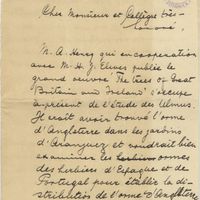
[Lettre], 1911 oct. 09, Herbarium, [Kew], [à Júlio Henriques, Coimbra]
Stapf, Otto
Manuscrito
[Lettre], 1914 fév. 14, Royal Gardens, Kew, [Londres], [à] J.[úlio] A. Henriques, Coimbra
Stapf, Otto
Manuscrito
[Lettre], 1914 mars 09, [Royal Gardens, Kew, Londres], [à Júlio Henriques, Coimbra]
Stapf, Otto
Manuscrito
[Lettre], 1921 fév. 15, Herbarium, Royal Botanic Gardens, Kew, [Londres], [à Júlio Henriques, Coimbra]
Stapf, Otto
Cartografia
Mediterranean : Africa : C. Tres Forcas to C. Ivi : surveyed by Captain E. Mouchez of the french Navy 1870-73
Wharton, W. J. L.
Cartografia
Mediterranean : Algeria : Algiers to C. Bougaroni : surveyed by Captain E. Mouchez of the french Navy 1867-9 : with corrections from the french gouvernment charts 1925-1926
Wharton, W. J. L.
Cartografia
Mediterranean : Algeria : Ports d'Oran and Mers-el-Kébir : from the french government chart of 1876 : with corrections to 1953
Edgell, J. A.
Cartografia
Mediterranean : Algeria : Tunis : C. Bougaroni to Fratelli Rocks including Galita Channel
Richards, G. H.
Cartografia
Mediterranean : Algeric : approaches to Bone : from french government chart 1889 : with corrections from the french government chart 1929
Wharton, W. J. L.
Cartografia
Mediterranean : Algérie : C. Ivi to Alger : from the french government charts of 1867-1870 : with additions and corrections to 1951
Wharton, W. J. L.
Cartografia
Mediterranean : Gibraltar : surveyed by Capt. R. M. Southern R. N. and officers of H. M. Surveying ship "Challenger" : 1947-1948
Day, A.
Cartografia
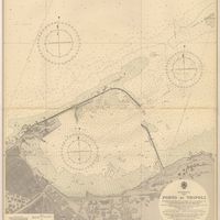
Mediterranean : Libya : Porto di Tripoli
Wyatt, Guy
Cartografia
Mediterranean : Tunisia : Baie de Tunis : from the french Gouvernment charts of 1893 : with corrections to 1953
Day, A.
Cartografia
Mediterranean : Tunisia : North Coast : Lac de Bizerte and Entrance : from french government charts to 1948 : with corrections to 1957
Edgell, J. A.
Cartografia
Mediterranean Sea : Algérie : C. Ferrat to C. Bougaroni : from the french government surveys of 1868-74 : the coast of Spain from spanish authorities
Richards, G. H.
Cartografia
Mediterranean Sea : Algeria : approaches to Alger : from the french government charts to 1932 : with corrections to 1950
Edgell, John
Cartografia
Mediterranean Sea : Algeria : Port d'Alger : from the french government chart of 1911 : with corrections to 1938
Purey-Cust, H. E.
Cartografia
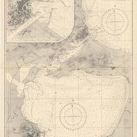
Mediterranean Sea : Egypt : Alexandria Harbour
Hardy, N. A. C.; Day, A.; Edgell, J. A.
Cartografia
Mediterranean Sea : Egypt : approaches to Port Said ; Port Said
Day, Archibald
Cartografia
Mediterranean Sea : Egypt : Damietta to El Arish
Douglas, H. P.
Cartografia
Mediterranean Sea : Europe Gibraltar to Alicante : Africa Cape Spartel to Cape Ferrat : from spanish and french government charts to 1877
Evans, F. J.
Cartografia
Mediterranean Sea : Marocco : Bahia de Ceuta : from the Spanish Gouvernment Chart of 1926 : with corrections to 1956
Douglas, H. P.
Cartografia
Mediterranean Sea : plans of the Coast of Libya : Rada and Porto di Tripoli : from the italian Gouvernment chart of 1930
Parry, J. F.
Cartografia
Mediterranean Sea : Tunisia : East Coast : approaches to Sfax : from the french Gouvernment charts to 1952 : with corrections to 1953
Collins, K. St. B.
Cartografia
Mediterranean Sea : Tunisia : East Coast : Kélibia to Tripoli : principally from french and italian Gouvernment charts to 1954
Collins, K. St. B.
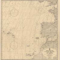
Cartografia
Portsmouth to Canary Islands (Islas Canarias) and the Azores (Açôres) : compiled from the latest information in the hydrographic Department, 1954
Wyatt, A. G. N.
Cartografia
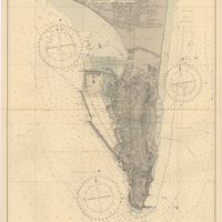
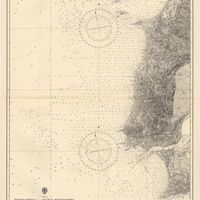
Portugal : Berlenga to Cabo Espichel including the approaches to Rio Tejo : compiled from portuguese government charts to 1935 : with additions and corrections to 1956
Wharton, W. J. L.
Cartografia
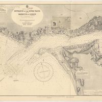
Portugal : West Coast : entrance of the River Tagus with the Harbour of Lisbon (Lisboa) : compiled from various Portuguese Government surveys to 1879 : with corrections to 1945
Richards, G. H.
Cartografia
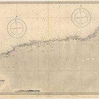
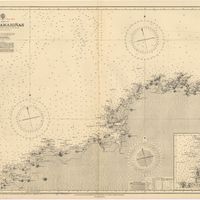
Spain : North Coast : Foz to Camariñas : from the spanish government charts of 1915 to 1920 : with additions and corrections to 1935
Edgell, J. A.
Cartografia
Spain : South Coast : Pta. del Acebuche to Pta. de la Chullera including Gibraltar Bay : from the spanish government charts of 1872-1914
Mostyn, A.
Cartografia
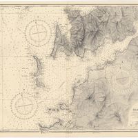
Spain : West Coast : Ria de Vigo : from the spanish government chart of 1912
Parry, J. F.
Cartografia
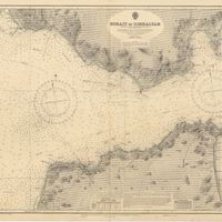
Strait of Gibraltar : from the spanish government charts of 1936 : with corrections to 1953
Edgell, J. A.
Cartografia
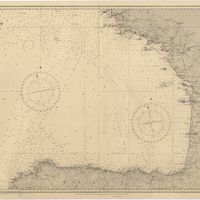
West coast of Spain and Portugal : Cabo Villano to Cabo de S.º Vicente : compiled from the latest information in the Hidrographic Office to 1958
Richards, G. H.